![]()
|
|
...a journey of a life time through ibn batuta's africa |
|
last position details day 10 date july 1
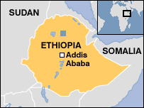
country
ethiopia town/area bahir dar/lalibela gps 11� 36 1.875 N 37� 23 9.057 E distance 03913 km
|
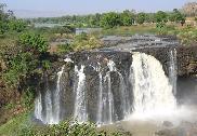
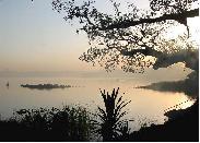
8:30am: yesterday after arriving in bahir dar, the group took a relaxing boat ride on lake tana, the source of the blue nile river. they got an early start this morning and are on their way to the blue nile falls and then to the rock churches of lalibela.
9:00pm: the scenery from bahir dar was beautiful as the group made their way to the blue nile falls. the falls are a 30 minute walk from the carpark and on the way, one crosses an old portugese stone bridge. the return walk was uphill and it got very hot. as of 9:00pm, they had still not reached lalibela and lots of lightening could be seen all around.
10:00pm: 3500 meters above sea level, the group has stopped in a village called dilbe. it is a cold 9 degrees celsius outside and they are 70km short of lalibela. they will spend the night in dilbe and continue the journey tomorrow. |
* stunning scenery along the drive
|
||
|
|
|
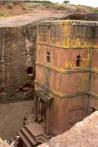 lalibela